
Why apply for a 40e permit?
A 40e permit allows you to prospect on a LIVE exploration tenement (displayed in green in ‘WA current tenements’).
See https://www.dmp.wa.gov.au/Minerals/Permit-Section-40E-over-granted-2421.aspx for more information.
Understanding the permit area
On your successful application for a 40E permit, you will receive a map of your area from DMIRS similar to that shown below.
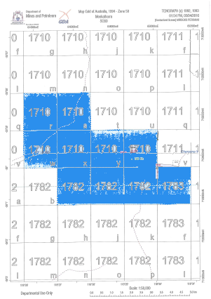
The permit will generally cover 10 ‘graticular blocks’ with each block being 1 minute by 1 minute – ie. 1/60 degree by 1/60 degree – in the same way that a minute in time is 1/60 hour. The boundaries of these blocks are labelled in degrees(°) and minutes(‘) – eg. -26°2’
You might notice that the 1-minute blocks are contained within a bigger 5-minute by 5-minute block – the bigger blocks are given a number – eg. 1710 in the example above. The 1-minute blocks are labelled a-z (but no ‘i’).
Applying for a 40e permit
As a part of applying for a 40e permit, you need to define the area for the permit in terms of 1-minute blocks. For each block, you need to name the block (a-z) and the 5-minute block that it falls within. You can use the ‘WA graticular blocks‘ overlay to get this information for any location in WA. Use this at home or in the field. See the screenshot at the bottom of this page.
Staying within the 40e permit area
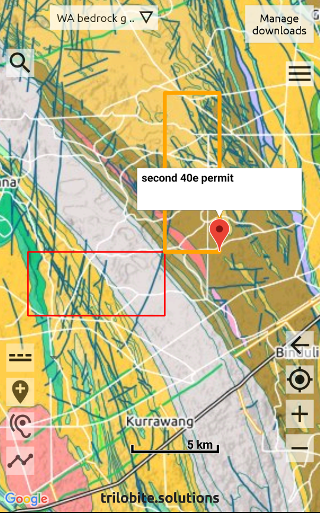
In the field you need to prospect only within the 40e permit area. By marking out the boundary in the Trilobite app you can check at any time that your current location (the blue circle) is within the 40e permit area. You can either mark the corners (simplest option) or mark out a ‘trail’ around the boundary – read the next 2 sections for details.
Mark the corners of your permit boundary (simplest)
- Download the ‘WA graticular blocks‘ map and set this as your overlay
- Zoom into the area of your 40e permit
- For each corner, zoom in to maximise accuracy, tap the teardrop icon
 . Tap ‘Tap on the map‘, then tap on the corner. Set the colour of the marker to something distinctive.
Mark a ‘trail’ along your permit boundary (alternative to marking the corners)
Convert the coordinates for each corner to decimal degrees using the conversion web page below. Leave the seconds value blank.
https://www.fcc.gov/media/radio/dms-decimal
Write the coordinates of the permit into a .csv file, and import this file into the Trilobite app – as per these details …
- on a PC, download and open the 40e_permits.csv file – click here
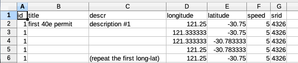
- replace the coordinates in the .csv file with the coordinates of your permit
- add more rows if your permit has more than 4 corners
- leave the srid values and speed values as is
- use the same id on all rows
- the first coordinate needs to be repeated in the final row
- save the .csv file, and email it to yourself
- on your phone/tablet, open the email, tap on the .csv file, and then choose to open it with the Trilobite app (
 )
)
Advising the explorer and DMIRS of gold finds
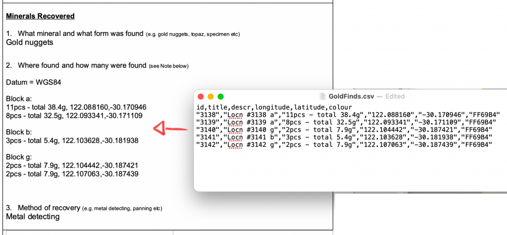
40e permit holders must advise the exploration licence holder and DMIRS of any mineral recovered once the permit has expired, or has been cancelled or surrendered. You need to complete a document downloadable from DMIRS called ‘Minerals-S40E_Minerals_Recovered.docx‘ at the time of writing, and also pen in the location of gold finds on the paper map of your 40e permit.
The following instructions describe the easiest way to transfer your gold finds recorded in the Trilobite app, into the DMIRS document, and to mark the locations on the paper map.
A reminder – regularly back up your gold finds data to CSV – in case you lose/break your phone.
Document (.docx)
- Within the app, tap on each gold find and add the graticular block to the title, so that you can later group the finds by block – eg. ‘Locn #24 a’
- Export (‘share’) all the locations in your 40e area to a .csv file.
- Open the .csv file on your computer using a text editor – eg. Notepad on Microsoft Windows or TextEdit.app on a Mac.
- Open the document ‘Minerals-S40E_Minerals_Recovered.docx‘ and copy the gold finds from the .csv file into the .docx file.
ie. descr, longitude, latitude
group the finds by block, and add the line ‘Datum=WGS84’
Paper map
- Run the Trilobite app, set ‘WA graticular blocks‘ as your overlay and zoom into your 40e area.
- Pencil in the locations on the paper map while referring to the Trilobite map.
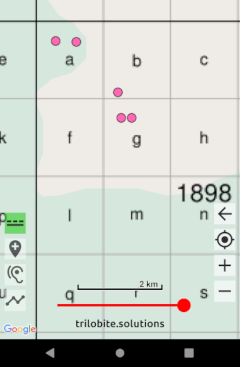
‘WA graticular blocks‘ set as the overlay