Download interactive maps to your phone or tablet so that you can access Ontario Geological Survey data at any time in the field, without any dependency on internet access. Your location is determined by your phone/tablet’s GPS and is shown on your screen at all times with a blue dot. The app is very simple to use and absolutely reliable. The equivalent Australian app is used by thousands of prospectors (testimonials).
There is a free 1-week trial for the App subscription ($CAD11.99/year). This is required to run the app. There is also an additional Professional subscription ($CAD11.99/year) that gives you access to more specialised data. To check when your trial ends or to cancel your subscriptions, tap on ‘My subscriptions’ in the app menu. No money leaves your account during the trial.
- Trial Ontario Field Geology Maps on an iPhone or iPad
- Trial Ontario Field Geology Maps on an Android phone or tablet
Features
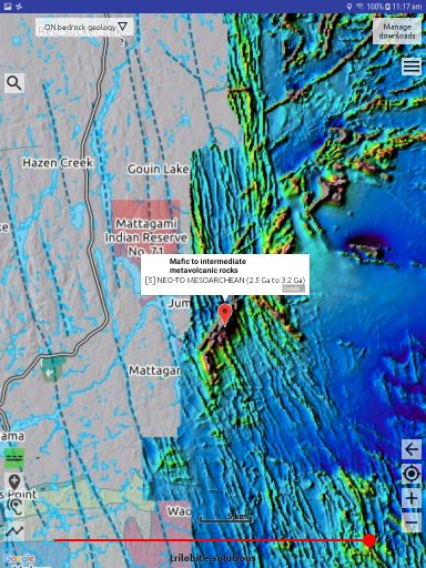
- bedrock geology map
- quaternary geology map
- symbolised resource map
- 21 resource data layers and U-Pb ages
- symbolised map of gold resources
- abandoned mines
- drill holes
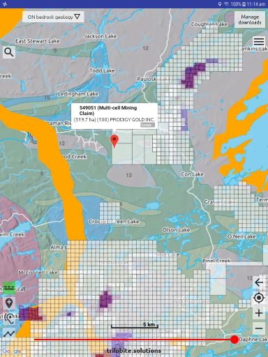
- mining tenure & claims map (updated daily)
- color aero-magnetics imagery
- record your tracks and write location notes
- place one map semi-transparently over another
- export tracks and notes to Google Earth or your GIS
- import tracks and location notes from Google Earth
- import geojson spatial data files and mbtiles maps
- extensive help, documentation, videos and support
Screen-shots