Testimonials

Apple – install/update app

Android – install/update app

General help

Instructional videos

User guide

Trouble-shooting

Training

Join our mailing list

Download poster

Other info

Backups & transferring data

Data rescue

Manage subscriptions

Recommended hardware

40e permit tips (WA)

Contact us

App features and screenshots

  • Ideal app for prospectors, fossickers, geologists, earth science students & educators
  • Runs on Android and Apple phones and tablets
  • Maps are downloaded to your phone so there is no dependancy on mobile reception in the field
  • Maps covering all of Australia & New Zealand
  • Trails and marked locations are private
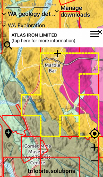
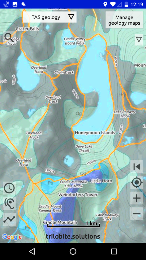
  • Simplified and detailed geology maps for all of Australia
  • Terrain is shown on the geology maps, so make more sense to non-geologists
  • Old mine workings, gold, gem and other metal finds
  • Gold distribution maps
  • Mining & exploration tenement information
  • Interactive – tap on maps to display detailed geology and resource information
  • Spoken geology – the app tells you when the geology changes as you drive – use this with the simple geology maps
  • Data is sourced from the state/provincial geological surveys and Geoscience Australia
  • Aero-magnetic imagery for all states/provinces
  • Bush-walking tracks shown with contours
  • Record your trail, so you can retrace your steps
  • Record notes on important locations – choose a colour for each marker
  • Export your field data to Google Earth or your GIS system
  • Import trails and locations created in Google Earth
  • Import data layers as geojson
Tenement data & bedrock geology, Western Australia


Cradle Mountain, Tasmania
Bush-waking tracks around Cradle Mountain, Tasmania


Maximise battery life
When you are bush-walking, please put your phone into flight mode. This can very significantly extend your battery life.

Acknowledgements
Thanks to the government organisations – Australian and otherwise – that have released their data under a Creative Commons BY license.  And gratitude to the generations of dedicated field geologists that have walked, ridden and driven over the remotest parts of our continents collecting data that forms the basis of our knowledge of the evolution of our continents. 

Warning about downloading very large maps on some Android phones
A few Android phones (eg. ZTE85/Telstra Tough Max 2 & ZTE84) will not download maps larger than 2GB.  This is not the fault of the app.  There is a get-around for this problem.  Please report this using the ‘Contact Us’ form if you have this problem.

Warning about iPads without SIM slots
The WIFI-only iPad does not have GPS hardware, so cannot determine your location in the field.  An iPad with a SIM slot is required for GPS functionality in the field.  (But you do NOT need to have a SIM inserted.)

Warning about iOS 13+
With iOS 13 and above, tracking and speaking might not work. If so, please run the ‘Settings‘ app, tap ‘Privacy‘, then ‘Location Services‘, and choose ‘ALWAYS‘ for Australian Geology Travel Maps. This problem is a result of Apple’s increased focus on data privacy.

About Trilobite Solutions

Experience
The author of Australian Geology Travel Maps is a geologist and software developer with over 35 years experience in information technology, including working in the mining and exploration industry and for Geoscience Australia and the Geological Survey of NSW.

Open Source
Trilobite Solutions uses and contributes to Open Source software.  This is used extensively in app development and data systems, for example, Ubuntu (linux) running PostGIS (a spatial database) and QGIS (an excellent free geographic information system).  Open source desktop applications are used in both the Mac OSX and Ubuntu environments.

Quality, Dependability & Simplicity
The driving design philosophies for all software developments are quality, dependability and simplicity. Apps need to make life simpler – and they must be totally reliable. The interface to the Trilobite Solutions apps is kept as simple as possible, and small hints guide the new user. Quality is the top priority in all aspects of development. Industry best practice defined by Google, Apple and the Open Source community are followed with all functionalities. And you are not on your own after you install the app – any stability issues with the apps are reported to Trilobite Solutions via a Google-provided monitoring system.

Field testing
Extensive hours of computing work has gone into the creation of the apps, including the creation of maps and the development of the Android and Apple apps, but to create a good field app requires first-hand experience in the field, and extensive testing in the environment that the app is designed for. The app is tested by the author regularly in the field in various locations around Australia.

Enjoy!
We hope you develop a fascination for geology and its relationship to landscapes, and you enjoy using your Trilobite Solutions app in the great outdoors of Australia and New Zealand.  If you are reading this from overseas, come over and see for yourself!

David Collins
Geologist and Developer
Trilobite Solutions

Author and assistant, Barraranna Gorge, South Australia

Contact us

Please read trouble-shooting first for common solutions. It will save you time.

    Your main device
    iPhoneiPadAndroid phoneAndroid tablet

    Where you are located right now?
    WANTSAQldNSWACTVicTasNZelsewhere

    You use our app primarily as a ..
    ProspectorGeologistFossickerTouristEducatorStudent

    Trilobite Solutions mailing list

    Sign up to our mailing list (1-2 emails per year) to get announcements about new features in the Trilobite Solutions apps

    Thank you for signing up.

    Something went wrong.